
FLOW is a proposal for the urban / landscape development of the Mississippi River along the city of St. Louis. It is an entry for the 2010 Steedman competition where it was awarded with a honorable mention.
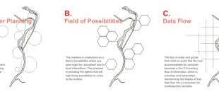
A.
Subtle Master Planning
Master planning is not attempting to impose any centrally decided, strict direction. It is supporting already existing elements and is providing the necessary infrastructure for possibilities to arise.
B.
Field of Possibilities
The riverbed is understood as a field of possibilities where any area might be ‘actualized’ due to local interactions. The proposal is providing the agents that will help those possibilities to come to the surface.
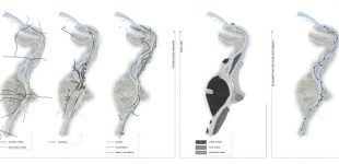
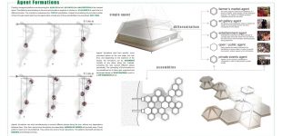
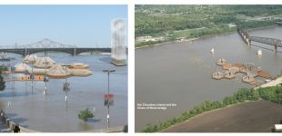
Floating, hexagonal platforms are becoming the agents that will actualize the possibilities of the riverbed areas. The platforms are traveling on the river and are able to organize in clusters or assemblies, each time in a different location. The riverbed is understood as a field of possibilities. Instead of actualizing only a limited number of them through master planning, the agents allow virtually any of those possibilities to be actualized over time.
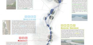
Agents’ formations start from specific, more prominent places on the river edge, but over time, and depending on the reactions of the people, the formations can be assembled virtually at any place along the riverbed, activating this way several different places periodically. The ‘spreading’ of the formations is not predefined but it rather gets organized and developed based on local reactions, much in a self-organized fashion.
Agents’ formations can exist simultaneously at several different places along the river, without any dependency between them. Over time, and as more formations are assembled, patterns of activity will normally arise. Those patterns need not to be predefined. They will be the result of local interactions. The patterns themselfs will also be dynamic and will keep evolving.
C.
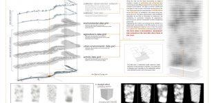
Data Flow
The flow of water and goods from north to south that the river accommodated for centuries becomes in the 21st century flow of information, which is controller and transmitted, transforming the display of that data flow into a monument for contemporary societies
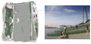
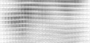
Along the river and the areas surrounding its edges is installed a system of monitoring and collecting data concerning several different aspects of the activities and the conditions encountered. The data is archived, studied and evaluated in order to help in the further development of the river. At the same time the collected data is transmitted live at the data tower, an installation in the center of the river, across the arch. The data is abstracted in a field of different intensities. As the flow of information is continuous, the installation is constantly changing its appearance, becoming a live, abstract visualization of what is happening on the river.
Engineering and control over physical forces defined to a great extent monumentality in the 20th century, as is most profoundly displayed in Saariner’s Arch. In the 21st century it is control over information flows that takes its place. The data tower is becoming a ‘monument’ that actualizes the invisible data flows of the river.
|
» info:
|
|
|
Design:
|
Dimitris Gourdoukis. |
|
Date:
|
2010. |
|
Awards:
|
— Steedman Competition 2010. Honorable Mention. |
|
Publications:
|
— “Projects” in (new) Panel Layout for Competition Seoul: DAMDI Publishing Co., 2012. |
|
Exhibitions:
|
— “Steedman Exhibition 2010” Washington University in St. Louis, School of Architecture, Summer 2010. |